Geographic Information Systems (GIS) has become a cornerstone of modern environmental leadership, offering unparalleled tools for assessing environmental impacts, monitoring environmental changes, and managing ecological risks. As environmental regulations tighten and sustainability becomes central to corporate and public agendas, GIS has proven to be transformative. Organizations using GIS for environmental monitoring report improved decision-making speed by up to 45%, while real-time GIS integration has enhanced predictive modeling accuracy by over 50% in environmental risk assessments. In today’s rapidly shifting landscape, GIS is not just a technology advantage—it is a strategic imperative.
This certified program is designed to equip environmental leaders with the critical GIS skills and in-depth understanding required to assess environmental impacts, conduct real-time monitoring, and evaluate ecological risks effectively. Throughout the program, you will explore foundational and advanced GIS applications in environmental science, including spatial data collection, environmental modeling, remote sensing, and geostatistical analysis. The program ensures that you acquire not only conceptual knowledge but also hands-on expertise with leading GIS platforms, enabling you to analyze real-world environmental scenarios with precision. You will gain the capability to predict ecological degradation, and design sustainable development strategies informed by accurate spatial intelligence.
Beyond core competencies, the program explores specialized applications such as cumulative environmental impact assessments, floodplain risk mapping and air as well as water quality monitoring. You will also learn how to harness GIS for regulatory compliance, environmental auditing, and stakeholder communication—skills critical for shaping policy, reporting, and public engagement. Additionally, the program emphasizes the integration of GIS with remote sensing technologies, environmental sensors, and big data analytics, enabling predictive forecasting and long-term risk evaluation.
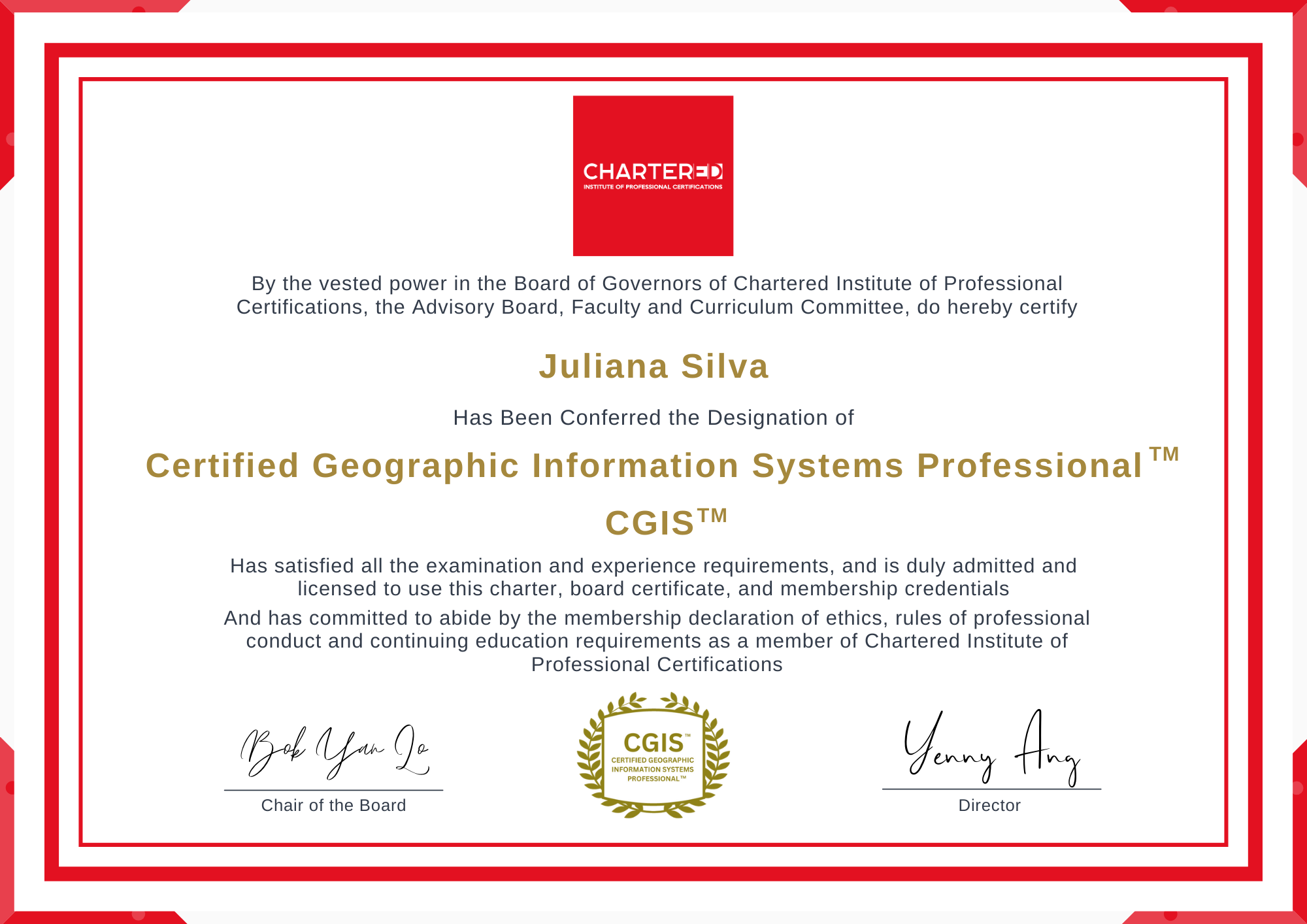
Upon successful completion of the program, you will earn the Certified Geographic Information Systems Professional (CGIS™)![]() designation, which will enhance your professional credentials and demonstrating your expertise in applying GIS to environmental compliance. This certification will not only elevate your professional standing among environmental practitioners but also positions you at the forefront of technological innovation in environmental management, opening pathways to leadership roles in conservation organizations, regulatory agencies, corporate sustainability departments, and environmental consulting firms worldwide.
designation, which will enhance your professional credentials and demonstrating your expertise in applying GIS to environmental compliance. This certification will not only elevate your professional standing among environmental practitioners but also positions you at the forefront of technological innovation in environmental management, opening pathways to leadership roles in conservation organizations, regulatory agencies, corporate sustainability departments, and environmental consulting firms worldwide.
1 Chartered Institute of Professional Certifications' reviews and ratings are a comprehensive collection of participants feedback we have gathered over the last decade. To view authentic and personal testimonials that are handwritten by our participants, please download our participants' written reviews here.
This program will entitle you:
Download Brochure Pricing & Registration- Experience 2 days of instructor-led live training designed to provide in-depth expertise in applying GIS for environmental impact, monitoring, and risk assessment. The program emphasizes practical applications of spatial data, remote sensing, and risk modelling to strengthen compliance, sustainability, and decision-making.
- Attain the industry-recognized Certified Geographic Information Systems Professional (CGIS™) designation. This certification will elevate your professional credentials and demonstrate your capability to leverage GIS tools for environmental compliance, resource management, and sustainability planning.
- Gain up-to-date expertise in integrating multi-source environmental data, conducting cumulative effects and risk assessments, and presenting results through compelling visualizations and dashboards, while aligning GIS applications with regulatory requirements, stakeholder engagement, and global sustainability goals.
- For inquiries, chat with our Program Advisers at advisor@charteredcertifications.com or call us at
- Singapore and Asia Pacific: +65 6716 9980
- Australia and New Zealand: +61 3 9909 7310
- UK, Europe and Middle East: +44 (020) 335 57898
- Canada: +1 833 879 8820
- USA: +1 888 745 8875
Accreditations
This program is accredited by the Chartered Institute of Professional Certifications, which maintains the governing standards for all professionals who have completed this program.
The content of this program has been fully certified and accredited by CPD Certification Service as conforming to Continuing Professional Principles. CPD is the leading independent CPD accreditation institution operating across industry sectors to complement the Continuing Professional Development policies of professional institutes and academic bodies. The CPD Certification Service provides support, advice and recognized independent CPD accreditation compatible with global CPD principles.
What Can You Expect From This Live Program
Geographic Information Systems (GIS) have become essential for environmental monitoring, impact analysis, and risk assessment. Powered by AI and IoT, GIS enables real time environmental monitoring, climate impact simulations, disaster management and pollution spread. By enhancing disaster risk management and supporting global sustainability initiatives, GIS plays a critical role in advancing climate resilience and addressing the growing demands of the rapidly expanding environmental monitoring market.
This certified program is designed to provide you with comprehensive knowledge and practical skills to apply GIS effectively in environmental impact, monitoring, and risk assessment contexts. You will explore key concepts on how GIS supports environmental assessment processes, risk evaluation, biodiversity conservation, climate adaptation, and sustainable resource management. You will gain the ability to acquire and integrate diverse environmental datasets, apply spatial analysis techniques, and use remote sensing, modeling, and visualization tools to generate actionable insights.
Through detailed sessions, you will learn to conduct cumulative effects assessments, model environmental risks such as floods, wildfires, and pollution, and manage complex applications like water resource monitoring and species habitat analysis. With real-world case studies you will understand the consequences of weak GIS integration in environmental decision-making and showcase best practices from global projects.
Furthermore, you will develop advanced skills in visual storytelling with GIS, transforming technical outputs into clear, compelling maps and dashboards that inform regulators, policymakers, and the public. Special emphasis will be placed on emerging practices, including stakeholder engagement, and the application of AI and machine learning in predictive environmental modeling. By the end of the program, you will have the knowledge, tools, and confidence to apply GIS strategically for compliance, sustainability, and risk mitigation.
![]() Upon successful completion of the program, you will attain the Certified Geographic Information Systems Professional (CGIS™) designation. This globally recognized certification will validate your expertise in leveraging GIS for sustainable decision-making and regulatory compliance. It will enhance your professional credibility and demonstrate your ability to bridge the gap between technical geospatial analysis and real-world environmental and policy challenges.
Upon successful completion of the program, you will attain the Certified Geographic Information Systems Professional (CGIS™) designation. This globally recognized certification will validate your expertise in leveraging GIS for sustainable decision-making and regulatory compliance. It will enhance your professional credibility and demonstrate your ability to bridge the gap between technical geospatial analysis and real-world environmental and policy challenges.
Key Skills You Will Gain
- Environmental Impact Analysis
- Spatial Data Management
- Remote Sensing Applications
- GIS-Based Risk Assessment
- Cumulative Effects Modeling
- Water Resource Mapping
- Biodiversity Monitoring
- Climate Change Modeling
- Disaster Risk Mapping
- Spatial Data Integration
- Policy and Regulatory Alignment
- Stakeholder Engagement Mapping
- Indigenous Knowledge Integration
- Cartographic Visualization
- Interactive Dashboard Design
- Geospatial Database Management
- Spatial Query Techniques
- Overlay & Buffer Analysis
- IoT Data Integration
- AI-Enhanced GIS Modeling
- 3D Environmental Simulation
- Habitat Connectivity Analysis
- Land Use Change Detection
- Pollution Hotspot Mapping
- Hydrological Modeling
- Ecosystem Services Valuation
- Environmental Compliance Reporting
- Scenario-Based GIS Simulation
- Evidence-Based Decision Support
- Communication of GIS Insights
Your Faculty Director

Dr. Jochen Albrecht, GISP, is an internationally recognized geospatial thought leader with over three decades of experience advancing the role of GIS across three continents. He has guided CEOs, senior executives, and policymakers in leveraging GIS as a strategic tool for environmental impact assessments, monitoring, and risk evaluation.
His expertise lies in integrating sustainability with GIS, applying environmental impact assessments, climate change and land use modeling, transportation and migration analysis to advance effective environmental management and strengthen resilience against global sustainability challenges. By combining rigorous qualitative and quantitative methods, Dr. Albrecht has helped organizations harness GIS for evidence-based decision-making, regulatory compliance, and long-term climate resilience.
Dr. Albrecht is the former President of the GIS Certification Institute, where he championed professional standards and elevated GIS as a driver of sustainable development and environmental governance worldwide. His leadership and insights continue to shape how GIS is applied to environmental monitoring, disaster preparedness, and policy innovation, ensuring that strategies are not only technologically advanced but also practical, ethical, and impactful.
Certified Geographic Information Systems (GIS) for Environmental Impact, Monitoring and Risk Assessment Program Agenda
How You Will Benefit
- Master Core GIS Competencies: Build a strong foundation in spatial data collection, modeling, and remote sensing to position yourself as a technical authority in environmental management.
- Conduct Geostatistical and Spatial Analyses: Apply advanced geostatistical techniques, spatial interpolation, and hotspot analysis to evaluate patterns and predict environmental risks with precision.
- Lead Environmental Impact Assessments: Gain the expertise to conduct rigorous assessments that strengthen compliance, safeguard ecosystems, and mitigate risks.
- Advance Environmental Monitoring: Implement cutting-edge GIS applications to track flood risks, air and water quality, and long-term ecological changes with confidence.
- Strengthen Compliance and Governance: Use GIS to meet regulatory demands, streamline audits, and deliver transparent reporting that builds trust with stakeholders.
- Harness Next-Generation Technologies: Integrate GIS with big data, sensors, and remote sensing to enhance predictive modeling and future-proof environmental strategies.
- Mitigate Environmental Risks: Model floods, wildfires, and pollution events to proactively manage risks and protect communities and biodiversity.
- Develop Advanced GIS Dashboards: Build dynamic, data-driven dashboards and 3D visualization tools that allow real-time monitoring and scenario modeling for decision-makers.
- Gain a Competitive Edge with AI: Apply AI and machine learning in GIS for advanced forecasting, giving you a strategic advantage in environmental leadership.
Certified Geographic Information Systems Professional (CGIS™)
Upon successfully completing this program, you will earn the Certified Geographic Information Systems Professional (CGIS™) designation, an industry-recognized credential with lifelong validity. This globally respected certification will validate your expertise in applying GIS to environmental assessments, risk modeling, and sustainability monitoring, while demonstrating your ability to integrate complex spatial data into compliance frameworks and policy decisions. A powerful addition to your professional profile, it highlights your commitment to excellence in geospatial intelligence and sustainable development. This program is developed by Chartered Institute of Professional Certifications and the content of this program has been certified by CPD Certification Service as conforming to continuing professional principles.
Pricing & Registration
Download Brochure
You can download our program brochure below. If you have any inquiries on this program, please contact our Program Advisor at advisor@charteredcertifications.com or call us at:
- Singapore and Asia Pacific: +65 6716 9980
- Australia and New Zealand: +61 3 9909 7310
- UK, Europe and Middle East: +44 (020) 335 57898
- Canada: +1 833 879 8820
- USA: +1 888 745 8875
Certified Geographic Information Systems (GIS) for Environmental Impact, Monitoring and Risk Assessment Reviews


Chartered Institute of Professional Certifications' reviews and ratings are a comprehensive collection of participants feedback we have gathered over the last decade. To view authentic and personal testimonials that are handwritten by our participants, please download our participants' written reviews here.
Convincing Your Boss To Attend This Program
Securing approval from your boss to attend this program can be difficult if you don’t know what to say. So, we’ve prepared a template for you! All you need to do is to download this template, copy and paste in email and send it to your boss!
Certified Geographic Information Systems (GIS) for Environmental Impact, Monitoring and Risk Assessment
4.8 (419 ratings)